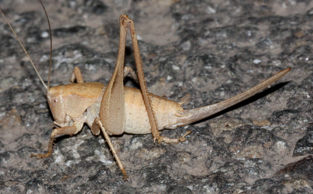


In email of 10 Dec 2010, Ron Lyons sent these details of the circumstances of his photographing living females of I. siskiyou:
Siskiyou Shieldback
These tended to be rather nervous as I manouvered to take pictures. I saw two individuals that I thought were males but they bounced off the road into the vegetation before I could photograph them. In one case, the female I photographed also had a pregnant scorpion on the road nearby!
The first 2 pictures are of the same individual. I thought this was an adult female, but now I'm not sure it is. The female in the third picture has a bit stronger color, but more importantly, the wings extend farther back and partially overlap along the midline. They are clearly separated in the first individual, so perhaps it is a last instar. The location for the first individual (2010 July 26) is given below. This is a few miles east of the type location of Thrall.
(Thrall does not appear in the 2008 Gazeteer for California. In California's Geographic Names: A Gazetteer of Historic and Modern Names of California by David L. Durham (c 2008?) get the following single entry:
"Ager [Siskiyou]: locality 24 miles west of Macdoel (Lat 41 52 N, Long.
122 27 30 W; at E line sec. 6 T 46 N, R 5 W); the place is along Willow Creek. Named on Copco (1954) 15' quadrangle. Postal authorities established Willow Creek Post Office in 1876, moved it 1.5 miles northeast in 1888 when they changed the name to Ager, and discontinued it in 1940; the name Ager was for Judson A. Ager, a pioneer settler.
Diller and others' (1915) map shows a place called Thrall situated along the railroad about 3 miles north-northwest of Ager. Postal authorities established Thrall Post Office in 1904, discontinued it the same year, reestablished it in 1905, and discontinued it in 1914; the name was for Will Thrall, a pioneer mountain man."
Ager is on the current map (Gazetteer 2008) at the appropriate coordinates and the appropriate distance from Macdoel. There is still a rail line going northwest out of Ager, so Thrall would appear to have been where the rail line bends to the west to follow the Klamath River.
(Copco Rd follows the north side of the river.) This appears to be the location of a small development now, based on the map. The time of the first paper, 1907, is consistent with the use of this name for the type locality given. Thrall is only 7-8 miles south of the Oregon border. I got the quoted information from Amazon writeup.)
Pictures 1 and 2
Siskiyou Shieldback (profile and pronotum views - possibly last instar)
Date: 2010 July 26
USA: CA: Siskiyou: Iron Gate Reservoir: Copco Road: mile marker 10.0: 41
57.170 N, 122 26.342 W, 2371 ft elevation
The second individual was photographed along Highway 263 north of Yreka. I don't have an exact location for this. I found the individual pictured a little bit north of the coordinates I have given so I used the word approx. I photographed another individual siskiyou at the coordinates given, but the pictures weren't as good. So, the one I included was taken along the same road, relatively nearby, but exactly how far away, I'm not sure.
Picture 3
Siskiyou Shieldback (adult)
Date: 2010 August 04
USA: CA: Siskiyou: Highway 263 north of Yreka: approx 41 47.223 N, 122
36.056 W, 2430 ft elevation