


restless bush cricket
Hapithus agitator
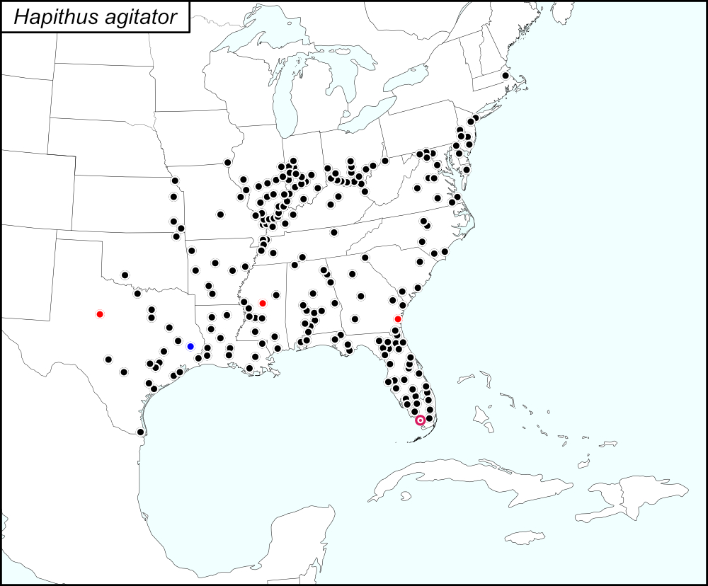

The black dots  on the distribution map represent county records from tblMain. Blue dots
  represent counties submitted by Wil Hershberger (West Virginia) and Brandon Woo (Massachusetts). The gold dots with crossbars
  represent records that were, in some combination, missing from one or two of the records references (tblMain, the original dot map, and the computer-generated map) while present on one or two of the records references (see Notes). The red target dot
  is placed on Monroe County, which is shown in greater detail in the map below.
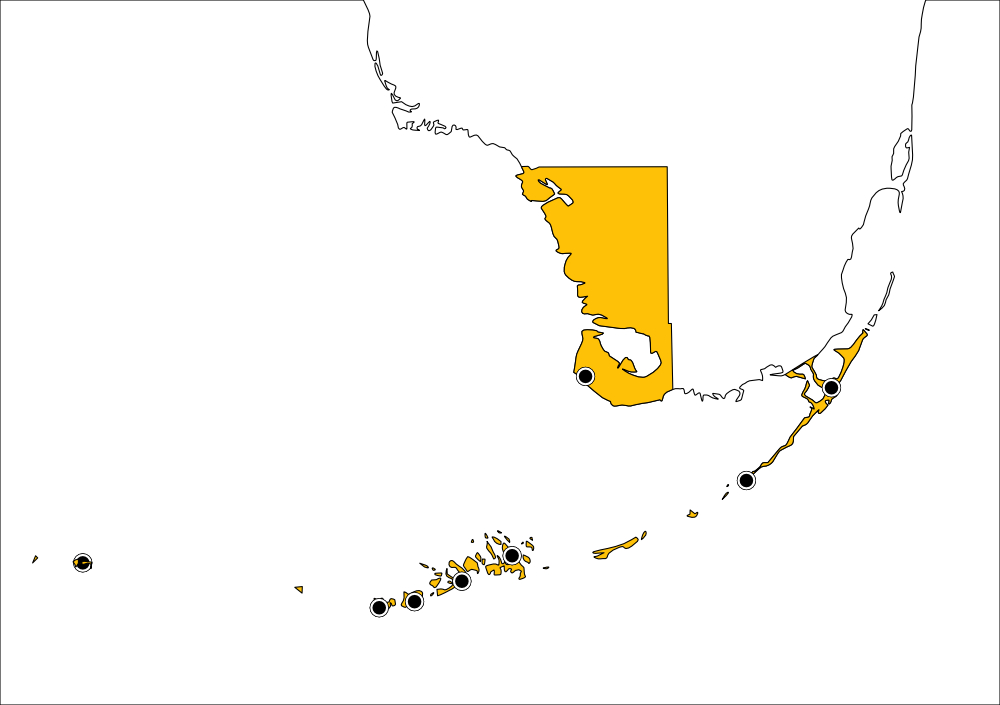
Monroe County, Florida includes the southwest portion of the tip of mainland Florida and the the Upper Keys, the Lower keys, and the Dry Tortugas. On the distribution map, a single red target dot
is placed at the center of the mainland portion of Monroe county. The above map shows the boundaries for Monroe County, highlighted in GOLD, and the localities for Monroe County from tblMain. Mainland: Cape Sable and Middle Cape (see Notes about these two records); east to west along the Keys: Key Largo, Matecumbe, Big Pine, Sugarloaf, Stock Island, Key West, and Dry Tortugas.
Summary of Species' Distribution
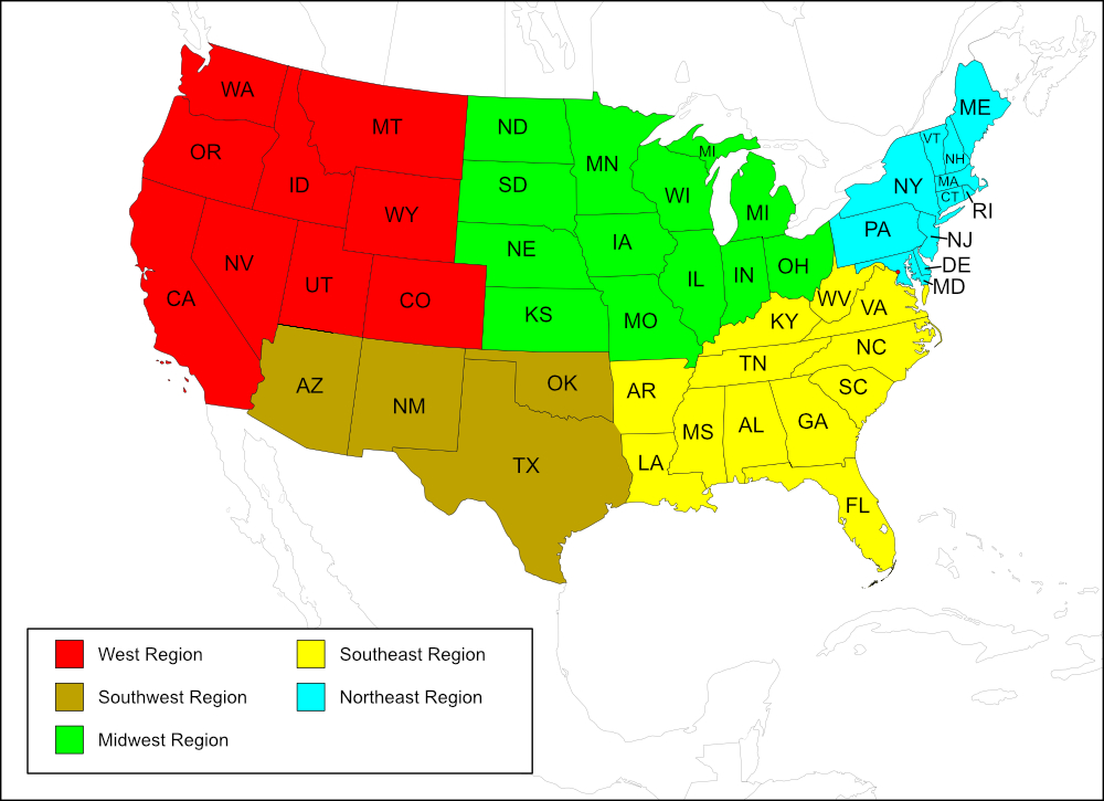
Hapithus agitator's range extends across the Southeast region of the United States and reaches eastward into the Southwest and northward into the Midwest and Northeast regions.
List of States and County Records
Map of
United States
Regions
Map of United States Regions
All records area from tblMain unless otherwise specified.
Southwest Region
State: Oklahoma
Comanche, Craig.
State: Texas
Counties: Anderson, Austin, Bexar, Brazoria, Calhoun, Cameron, Colorado, Dallas, Ellis, Fayette, Galveston, Grimes, Kerr, Montague, Orange, Trinity, Victoria.
Midwest Region
State: Illinois
Counties: Alexander, Clay, Coles, Edgar, Gallatin, Hardin, Jackson, Jersey, Johnson, Lawrence, Marion, Massac, Montgomery, Pope, Pulaski, Scott, Shelby, Union, Vermilion, Washington, White.
State: Indiana
Counties: Brown, Crawford, Fountain, Gibson, Greene, Jefferson, Knox, Monroe, Montgomery, Morgan, Parke, Posey, Putnam, Shelby, Tippecanoe, Vigo.
State: Iowa
Counties: Lee.
State: Kansas
Counties: Cherokee, Doniphan, Douglas, Neosho.
State: Missouri
Counties: Perry, Pulaski, St Charles.
State: Ohio
Counties: Adams, Athens, Brown, Clermont, Franklin, Hamilton, Jackson, Lawrence, Pickaway, Preble, Ross, Scioto, Warren, Washington.
Southeast Region
State: Alabama
Counties: Baldwin, Butler, Cherokee, Cleburne, Conecuh, Dallas, De Kalb, Escambia, Lauderdale, Lee, Lowndes, Monroe, Montgomery, Perry, Shelby.
State: Arkansas
Counties: Clark, Conway, Ouachita, Prairie, Scott, St Francis, Washington.
District of Columbia
State: Florida
Counties: Alachua, Brevard, Broward, Charlotte, Citrus, Clay, Collier, Dade, Duval, Escambia, Franklin, Gilchrist, Glades, Hendry, Highlands, Hillsborough, Jackson, Lee, Leon, Levy, Liberty, Manatee, Martin, Monroe, Nassau, Orange, Palm Beach, Pinellas, Polk, Putnam, Seminole, St Johns, St Lucie, Suwannee, Union, Volusia, Washington.
State: Georgia
Counties: Bibb, Bulloch, Chatham, Dougherty, Glynn, Gwinnett.
State: Kentucky
Counties: Bourbon, Caldwell, Mc Cracken, Mc Lean, Mercer.
State: Louisiana
Parishes: Beauregard, Bienville, Calcasieu, Lafayette, Natchitoches, Ouachita, Rapides, St John the Baptist, St Landry, Terrebonne, Washington.
State: Mississippi
Counties: Forrest, Harrison, Hinds, Lincoln, Oktibbeha, Rankin, Sharkey, Warren, Washington.
State: North Carolina
Counties: Columbus, Durham, Hoke, New Hanover, Wake.
State: South Carolina
Counties: Charleston, Florence, Hampton, Oconee.
State: Tennessee
Counties: Dyer, Fentress, Giles, Lake, Lauderdale, Madison, Obion.
State: Virginia
Counties: Dinwiddie, Nelson, Orange, Spotsylvania.
Independent cities: Fairfax, Norfolk, Suffolk.
State: West Virginia.
Counties: Wayne, Wetzel.
Records from Wil Hershberger
Counties: Jefferson, Morgan.
Northeast Region
State: Delaware
Counties: Sussex, Kent, New Castle.
State: Maryland
Counties: Worcester.
Records from Wil Hershberger
Counties: Frederick, Washington.
State: Massachusetts
Records from Brandon Woo
Counties: Suffolk.
State: New Jersey
Counties: Atlantic, Burlington.
State: New York
Counties: Queens, Richmond.
State: Pennsylvania
Counties: Bucks, Philadelphia.
Notes
References:
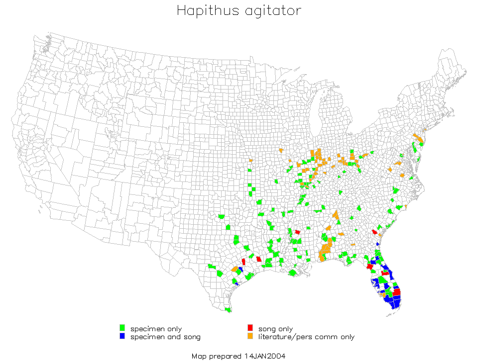
The distribution map on this page is referred to as the 2024 distribution map.
While proof-reading the records for this page, I noticed that I had given a dot for Cape Sable, Monroe County, but wrote the entry as Middle Cape Sable. I checked tblMain and saw that the entry was given as "Middle Cape Sable EVNP". There have been other entries in tblMain where 2 localities are given for one entry. I am unsure if this entry meant Middle Cape, Cape Sable, or both. I added blue dots to represent these two locations (Cape Sable, upper dot; Middle Cape, lower dot) and changed the localites list frome "Middle Cape Sable" to "Cape Sable and Middle Cape" with a link to these notes. EVNP stands for Everglades National Park. [tmy 29 May 2025]
Delaware: One entry on tblMain did not have a county record; a dot was not added to the 2024 distribution map for that entry.
Florida: In tblMain, Bradenton, which is located in Manatee County, was listed under Monroe County and there were 12 records for Monroe County that did not give a locality.
Georgia: Glynn County was not on tblMain but was on the original dot map and the Computer-generated map; a dot was added to the 2024 distribution map.
Illinois: The following counties were on tblMain and the computer-generated map but not on the original dot map; dots were added to the 2024 distribution map: Alexander, Clay, Gallatin, Hardin, Massac, Pulaski, and Vermilion.
Maryland: In 2022, Wil Hershberger submitted the records for Frederick County (collected in Libertytown, 19 September 1998) and Washington County (collected at C&O Canal, 1 September 2011).
Massachusetts: Suffolk County is a record that was submitted by Brandon Woo in October 2017. Woo collected the specimen in a small city park.
Mississippi: Holmes County was not in tblMain but was on the original dot map and on the computer-generated map.
Nebraska: 1 entry on tblMain but no county was given; a dot was not added to 2024 distribution map.
Texas: Tyler County was not in tblMain but was on the original dot map and the computer-generated map. A dot was added to the 2024 distribution map. Another dot was on the original dot map but not in tblMain or on the computer-generated map; it is probably on of these 4 counties: Fisher, Jones, Nolan, or Taylor. A dot was added to 2024 distribution map.
West virginia: In 2022, Wil Hershberger submitted the records for Jefferson County (collected in Kearnesyville, 20 August 2004) and Morgan County (collected at Old Farm Lane, 25 August 2020). [tmy 10 December 2024]