


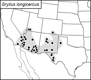
long cercus field cricket
Gryllus longicercus
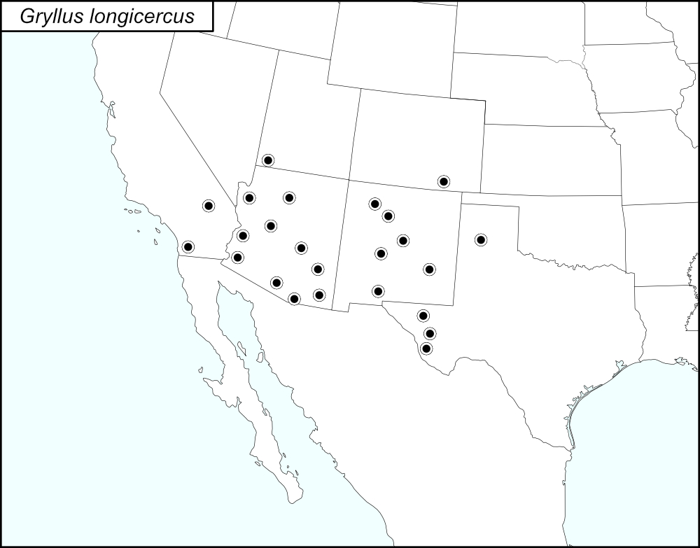

The black dots  on the distribution map represent county records.
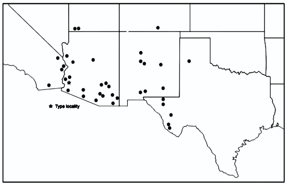
The above map is from Weissman and Gray (2019) and shows the localities for Gryllus longicercus as given in their publication. Those localities are listed below by state and county.
State: Arizona
Cochise County: Bisbee. Portal. Chiricahua Mountains, Fort Bowie.
Coconino County: Sedona. Highway 89A, 1 mile south of intersection with Highway 179. 2.6 miles north of Sedona.
Gila County: Coolidge Dam.
Graham County: 7-10 miles northwest of Bylas. Pinaleño Mountains, Mount Graham.
La Paz County: 18-35 miles north of Wendon on the road to Alamo Dam.
Mohave County: Burro Creek Campground. Quartzsite. Kingman. Road to Hualapai Mountain Park, Southeast Kingman.
Pima County: Ajo. Highway 85, 13 miles north of Ajo. Baboquivari Mountains, Brown Canyon. Kitt Peak, Highway 386, 5.1 miles from Highway 86. Kitt Peak picnic area, 10.5 miles from Highway 86. Near Sonora Desert Museum. Organ Pipe Cactus National Monument Campground. Santa Catalina Moutains, Mount Lemmon Recreational Area. Tucson. Why.
Santa Cruz County: Madera Canyon, Bog Springs campground.
Yavapai County: Highway 179 on the west side of Sedona.
Yuma County: Telegraph Pass. Kofa National Wildlife Refuge, Palm Canyon.
State: California
San Bernardino County: Providence Mountains State Recreational Area. Havasu City. 14 miles north of Vidal.
San Diego County: Road S22 from 2.7 to 10 miles southwest of Borrego springs.
State: Colorado
Las Animas County: Trinidad Lake State Park, Carpios Ridge Campground.
State: New Mexico
Bernalillo County: Tijeras Canyon about 2 miles west of Tijeras.
Chaves County: Highway 380, 7.3 miles east of Roswell at mile post 163.4. Highway 82, about 33 miles west of Artesia.
Doña Ana County: Organ Mountains, Aguirre Springs Recreational Area. Tortugas Mountains, near University of New Mexico, Las Cruces.
Sandoval County: Jemez Pueblo.
Socorro County: Los Pinos Mountain, Goat Draw, 4.5 miles north of highway 60. Highway 60, 34 degrees, 24 minutes, 12.07 seconds; -106 degrees, 30 minutes, 29.16 seconds. Sevilleta National Wildlife Refuge.
Torrance County: Highway 60 Rocky Road Cut southwest Mountainair.
State: Texas
Culberson County: Guadalupe Mountains, 4.4 kilometers northeast of Pine Springs. I10, 8 miles west of Van Horn, mile post 133.
Jeff Davis County: Davis Mountains.
Presidio County: Chianti Mountains, Highway 67, 0.5 miles north of Shafter. Highway 67, just south of Shafter.
Randall County: Palo Duro Canyon State Park.
State: Utah
Washington County: Springdale. 2 miles east of west entrance to Zion National Park. Just west of Zion National Park west entrance.
Summary of Species' SINA Distribution*
Gryllus longicercus is found in the West (southern California, Colorado, and Utah) and Southwest (throughout Arizona and New Mexico and eastern Texas) Regions of the United States.
*North America, north of Mexico.
List of United States Regions, States, and Counties
Map of
United States
Regions
Map of United States Regions
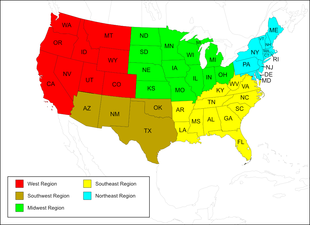
West Region
State: California
Counties: San Bernardino, San Diego.
State: Colorado
Counties: Las Animas.
State: Utah
Counties: Washington.
Southwest Region
State: Arizona
Counties: Cochise, Coconino, Gila, Graham, La Paz, Mohave, Pima, Santa Cruz, Yavapai, Yuma.
State: New Mexico
Counties: Bernalillo, Chaves, Doña Ana, Sandoval, Socorro, Torrance.
State: Texas
Counties: Culberson, Jeff Davis, Presidio, Randall.
Notes
References:
The distribution map on this page is referred to as the 2024 distribution map.
All records are from Weissman and Gray (2019). [tmy 13 July 2025]