


ovate shieldback
Aglaothorax ovatus


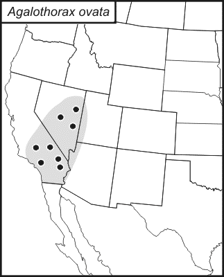
The black dots  on the distribution map represent county records from tblMain. The green target dots
  represent county records that are in tblMain and Cole et al. (2025).

The above map shows the localities for the Ovatus Group species from Cole et al. (2025). The light blue dots (encircled in a black line*) show localities for A. ovatus.
State: California
Los Angeles County:
Northern Los Angeles County where the fringes of the Mojave Desert meet the north slope of the San Gabriel Mountains.
2 miles south of State Highway 138 on County Road 4.
4.5 miles west of Desert Springs on Highway 138.
Bob’s Gap, 4 miles north of County Road N4 on Bob’s Gap Road.
County Road N4 near Llano.
Largo Vista Road (county Road N4) at Fort Tejon Road.
Largo Vista Road (county Road N4), 1 mile south of Fort Tejon Road.
Acton Canyon, Sierra Highway, 0.5 miles east of Crown Valley Road.
Edwards Air Force Base, 165th St.
Mint Canyon.
Old Nadeau Road at Pearblossom Highway, 5 miles south of Palmdale.
Palmdale.
Palmdale, 5 miles east.
Sierra Highway, 0.6 miles west of Crown Valley Road, Acton.
Kern County:
East side of Sierra Nevada below Walker Pass.
Walker Pass.
1.3 miles east of Walker Pass on State Highway 178.
Freeman Canyon, 1.5 miles southeast of Walker Pass on SR178.
Freeman Canyon, 2 miles west of Summit on SR178.
Freeman Canyon, 3.3 miles northwest of SR14 on SR178.
Freeman Canyon, SR178 3 miles west of SR14.
Jawbone Butterbredt Area of Critical Environmental Concern.
10 miles south of Inyokern.
3 miles west of junction Highways 178 and 14 on Highway 178.
3.7 miles east of Sopp Rd and Powerline Road.
32 miles north of Mojave.
About 0.5 miles south of junction Highways 14 and 178 on Highway 14.
About 10 miles northwest of Inyokern, Short Canyon.
Edwards Air Force Base, East Rosamond Hills.
Jawbone Canyon.
Junction of Backus Road and Tehachapi Willow Springs Road.
Mojave Desert, Randsburg.
Red Rock Canyon Park, on plateau north of park off Highway 14, 30 miles north of Mojave.
Sierra Nevada, Jawbone Canyon.
4.5 miles south of SR178.
Tehachapi Pass.
Wheeler Ridge.
Inyo County:
Argus Mountains, northeast of Ridgecrest.
Argus Range, Birchum Spring.
Argus.
China Lake Naval Air Weapons Station, Haiwee Spring.
China Lake Naval Air Weapons Station, Lower Haiwee Spring.
China Lake Naval Air Weapons Station, Mountain Springs Canyon.
China Lake Naval Air Weapons Station, Birchum Spring.
San Bernardino County:
China Lake Naval Air Weapons Station, Mountain Springs Canyon, Eagle Crags, Mesquite Spring.
Coolgardie Road, 3.3 miles northwest of Copper City Road.
Copper City Road, 4.7 miles north of Irwin Road, Barstow.
Copper City Road, 5 miles north of Irwin Road, Barstow.
Desert Springs.
Granite Mountains wash, 2 miles southwest of SR247 off Spinel Street.
Mountain Pass.
*Line encircling the locality dots was added to the map by the SINA editor (tmy) to help the viewer pick out the dots; this is not an indication of range or distribution.
Summary of Species' SINA Distribution*
Aglaothorax ovatus is found in the Mojave Desert of California.
*North America, north of Mexico.
List of United States Regions, States, and Counties
Map of
United States
Regions
Map of United States Regions
Region
State: California
Records from tblMain
Counties: Riverside.
Records from tblMain and Cole et al.
Counties: Inyo, Kern, Los Angeles, San Bernardino.
State: Nevada
Records from tblMain
Counties: Lincoln, Nye, White Pine.
Notes
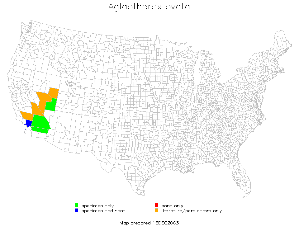
The distribution map on this page is referred to as the 2024 distribution map.
The computer-generated map, original dot map, and tblMain records are in agreement. The four counties from Cole et al. (2025) are also in tblMain. [tmy 15 January 2026]